We made it to Sydney today with no problem. I had to jump online for something else, so I thought I'd post a quick entry, although I don't have much to say. We had to get up VERY early (3:45) to catch our flight (I know.... again, I can feel the sympathy pouring in). When Keith was complaining yesterday about how early we would have to get up I reminded him that most folks back home have to get up around 6:00 or so every day to go to work....I don't think we have much room to complain. Nevertheless, he is upstairs napping right now and as I can't ever seem to nap for very long, thought I'd take care of some stuff online.
We're staying a ways out of downtown Sydney at another YHA hostel, but being the large city that it is, Sydney is set up with a pretty sweet subway/bus/train/ferry system, and the first thing we purchased was a weeklong pass to ride any of them at any time. So while we're not staying right downtown, it's not too much trouble to get there and actually kind of nice to be able to escape from it. I do have to admit that we would have stayed downtown, but apparently December is the busiest travel month for Sydney and waiting until the day before to book a double room in a hostel doesn't cut it - all the places that we knew would be good places to stay were full and we didn't want to risk getting stuck in a dive for the five days we're here. So we ended up in a suburb called Dulwich Hill - maybe a 20 minute drive from downtown - 30 min by subway. It's an interesting community - I'm trying to figure out the predominant nationality and have narrowed it down to Greek or Italian. We went to the bank first thing to get some money and were greeting with a HUGE line of people - all very short and speaking a different language. I heard lots of Italian, but lots also looked Greek to me (ha, no pun intended). We quickly learned, by chatting with the very cute and chatty old lady next to us, that today is "pension day". Apparently not a lot of people utilizing direct deposits for their pension check - they were all at the bank to get their cash. I even saw one lady immediately stuff it all into her bra!
It's not a touristy part of the greater Sydney area at all, and we found that our hostel caters to the travelers on working holiday. It's kind of nice in a way to just be in a regular neighborhood without the bombardment of tourist activities, which you really can't get away from in NZ. And with such a diverse population in this particular neighborhood - it really does feel like a foreign country - although not at all what I expected Australia to be like. We stuck out like sore thumbs at the bank today....it made us realize how much more we're going to stick out 5 days from now when we land in Bali! We may venture into the city tonight, we'll see if Keith ever wakes up....don't worry Melody, I'll let him sleep! :)
I just looked at the beginning of this blog....looks like I had more to say than I thought!
Wednesday, November 30, 2005
Monday, November 28, 2005
Queenstown back to Christchurch
Ok, aparrently it is my turn at the blog. My engineering mind tells me that the most efficient typer should do the blogging. Em types like a 'rat on a cheeto', I, however, am a bit slower. I think she left off as we got off the Routburne track and stayed the night in Queenstown. We ended up renting a car, as it was the cheapest way to see all the sights we wanted on our four-day trip back to Christchurch. After leaving Queenstown we headed to Wanaka, a small town set in the mountains. We hiked a 3 hour hike that took us up a valley to the Rob Roy Glacier. It was a very nice hike, but none of our pictures turned out great, so none are included. We camped along the river at DOC campsite....saving a few $$!!.
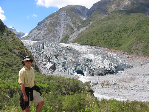
The next day we drove to Fox Glacier, one of two glaciers that drop very close to the Tasman see on the West Coast. We hiked to the terminus of the glacier where we sat and watched it melt away...literally. The glacier slides down the valley at the high speed of 1.5 meter/day...10x faster than glaciers in the Alps. It melts even faster, so the glacier is actually retreating up the valley. I am sure the coal we have been burning in our Alpine huts had nothing to do with it...
Fox Glacier
We stayed in a hostel in the coastal town of Hokitika, a small town the had the feel of many towns on the coast of Oregon. It is known as one of the few places where greenstone or jade is found and the town is lined with jewlery shops. Em found a nice jade necklace...one of our few souveniers for NZ.
The next morning we headed to Arthur's Pass where we ate lunch and did a short waterfall hike. It my effort to get a great picture of me in front of the waterfall....I fell in!! Em was there to help by laughing and taking a picture....not included in the blog.
We headed down the pass and stopped to walk through a limestone cave...called "Cave Stream" Cave.....very original and very decsriptive. This short, 1 hr hike was one of the best things we've done. It is very much like the slot canyons of Utah, in a cave form. The water was about waist deep in places.
Entering the cave: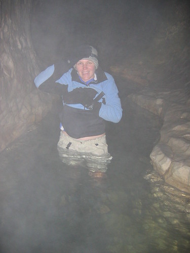
Waterfall: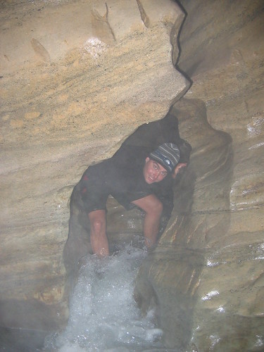
After camping the night at a free campsite...yeah!...we headed to Christchurch, where we are now. We head to Sydney on the 1st for 4 nights.
Cheers!
Thursday, November 24, 2005
Milford Sound and more Tramping
Friday, November 26, 2005
Happy Thanksgiving! As I type this you all back home are enjoying cozy, turkey dinners with friends and family. I hope you are all enjoying!!
We're back from our 6 day adventure in the southland sounds and alpine areas. If you want to cruise on down to the last entry about the Kepler Track, I've put some photos up. We are in Queenstown right now - still on the southwest corner of the South Island. Queenstown is another tourist/adventure haven. We're just lying low and resting, bypassing the touristy stuff. We only have 6 days left and have decided to rent a car for those days so we can stop along the way without having to spend so much time figuring out bus schedules and how to get to the last few side trips we want to do. Being on the south part of the island is an advantage as well, because you can get nice deals on rental cars. The companies need their cars moved back up north because so many travelers travel from north to south, then fly out. Anyway, below is again my journaling of the hiking and kayaking we did. Again, it may be too boring for most. The Readers Digest version is that everything went well and was beautiful, except for one miserable day on the trail, where we got a taste of the unpredictable, at times unpleasant NZ weather that everyone keeps warning us about. So read on at your own leisure.....
Sat, November 19, 2005:
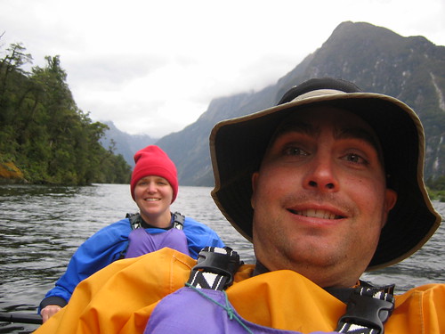
The dramatic beauty of the Milford Sound. We got to see it by kayaking rather than aboard one of the many cruise ships that make their way around the sound - or is it a fiord? The technical definition of a sound is a water filled valley that was carved out by a river. And a fiord is one that was carved out by a glacier. (Am I right dad?) The valleys of where we kayaked were carved by glaciers, so technically it should be called the Milford Fiord, right? Well, our guide today said they have compensated for this fact by naming the whole area Fiordlands National Park. Whatever the correct geological name, it was stunning. The Milford Sound is one of the only of the many sounds that line the West Coast of the southern half of the south island that is accessible to people by car. Doubtful Sound is the other one and requires a long drive, a boat ride, then another drive over a pass. The land is quite remote here. You can get to other parts of the park also by helicopter or plane, by walking some very difficult tracks, or by boat via the Tasman Sea.
Even getting to Milford is a bit of work (or time at least). From Te Anau (the last major town before the sound) it is about a 2 hour drive to Milford Sound via what is supposedly the famous Milford Road. A very long, winding and beautiful drive. We got picked up at the ungodly (for us vacationers anyway) hour of 6:30 AM by the kayak company to make the journey. The first part was nondescript, but once we started gaining elevation and after passing through Homer Tunnel, we started getting more dramatic views. Eventually we had our first view of the sound and it was a beaut. Essentially, it looks like mountains that have been submerged. Very steep, tree-covered cliffs that plunge right into the water and peaks towering high above.
The weather was marginal. Cloudy, and looking like it could rain at any time, but very calm water. We got geared up, safety talk done, then hit the water. Keith and I in a double and three other couples and our guide. We took our time circling the sound and enjoying the views. Of course Keith and I would have liked to have gone further out into the sound, but that is one of the problems with guided tours - you have to go where they tell you. On the other hand our guide was awesome and gave us lots of good information about the area. For wildlife we saw lots of penguins and one seal. We had a leisurely lunch stop, a peak at where the famous Milford Track ends, then were back to teh docks by 3:00. We never did get rained on - it got a tad bit windier, but no rain which was nice. The sandflies down here though....yikes are they bad! There's a Maori story saying that one of the gods created them to keep people away from the beauty of the area so as not to destroy it.
Here's us in the kayak:
And a view of Mitre Peak - one of the most photographed parts of the sound:

After kayaking we had a quick tour of Milford, which consists of a pub, a lodge, and a cruise boat terminal where 6,000(!) people a day take motor boat cruises around the sound. The van stopped to take in some views on the way back, and some hot drinks and biscuits (cookies), then we got dropped off at the Divide (where the mountain ranges split the east and west sides of the island). From here we started our 5 day hike.
The original plan was to just do the Routeburn Track - another Great Walk. But it is not a loop track and the logistics of getting back to where you started to pick up the rest of your stuff is a nightmare and a ton of driving. So we created our own loop track by combining the Caples Track with the Routeburn, which only involved one shuttle (and a stay in a lodge!) to get from the end of the Caples to the beginning of the Routeburn. So to start we headed up the Routeburn from the Divide for about an hour after which we turned off onto the Greenstone/Caples track. This portion was not a Great Walk so camping is free and the huts are much cheaper at only $10 per person. 20 minutes into this trail, we arrived at our campsite for the fist night. We brought our tent and sleeping pads in this far, close to where the trail divides, with the plan to stash them, stay in huts the rest of the time and pick them up on our way out.
There is one thing I think I forgot to mention about the Kepler Track and great walks in general. While you do have to pay a premium, what you get for it is almost worth it. The huts are very well set up with sleeping bunks (with nice pads), cooking facilities, drinkable water, flush toilets. What this means is you save a LOT of weight by staying in them, and packs become considerably lighter. We became quite spoiled in this way on the Kepler, so we opted for the huts the rest of the way on this walk for the weight factor as well as the unpredictable weather factor. Tents can only stay dry for so long.
So there you are, rambling as usual. We got to camp by 6:00 PM and set up the tent just as the rain started. We ate dinner, and quickly climbed in to sleep. The forecast calls for rain all day tomorrow, so we are preparing for the worst, but hoping for a break.
Sunday, November 20, 2005:
We we knew if we kept glowing about how lucky we have been with the weather it was going to come up and bite us in the ass at some point. Unfortunately the forecast was dead on. It rained ALL DAY today. Not even a pause. We got absolutely soaked. Our worst day hiking probably ever (although as I sit here typing this now, it doesn't seem like it was all that bad). I guess we couldn't come away from NZ without one hike like this. Glad it wasn't on the Routeburn where the truly spectacular views are supposed to be. It rained all night on us, and I think the guy at customs who washed our tent, washed some of the waterproofing off because by morning rain was starting to drip through. We woke up early but stayed in bed waiting for "the rain to stop". Ha. We'd still be lying there waiting!
We finally bit the bullet, donned all the raingear we had (of which Keith has very little). I just bought some waterproof pants, and boy am I glad I did. We packed up quickly, stashed the tent and off we went. Given the pounding rain, gusty wind, and knowledge that we had to go up and cross over a saddle, I sort of wanted to go on the other track that follows another river (but would entail more mileage). However, since we forgot the maps (just what our parents want to hear - lacking in raingear, alpine crossings and no map) we didn't know if we'd make our bus on the other side, so we stuck with the original plan. We quickly learned the defnition of Great Walks (of which this isn't). Great Walk = great track, great track maintenance, great signage, and great huts. This trail sucked. Very narrow, steep, and completely root laden. Anyone who has hiked at all, knows how slippery a wet root can be. That is all we've been walking on is roots. We did OK the first hour dealing with it all. As we got closer to treeline, I started to break down (I think I was literally whimpering there for a second).
Then we broke treeline and yes, the wind was fierce and the rain harder and colder. But Keith assured me we wouldn't be up there long and the trail had miraculously become easy walking. So we booked it, finally being able to walk faster and our spirits a little lighter (this is 2.5 hours from the start). Then we started heading back down into the valley on the other side and lo-and-behold the trail begain to deteriorate again. They did have good markings on the trees so we were never in danger of losing the trail, it was just really hard walking. At this point Keith's jacket is starting to soak through and my waterproof shoes are no longer waterproof. At about 3 hours from start, and know Keith is having a little breakdown as he is pretty much soaked from head to foot. We are both tired and the rain shows no sign of letting up. I have got to hand it to the polypro/fleece/wool gear - you do stay warm, even when wet. Moving helps of course as well. I thought my hands would be goners buy I kept my saturated fleece gloves on and they (my hands) stayed warm the whole time.
Eventually, we both stopped complaining and buckled down and dealt with the misery of it and had as much fun with it as we could. With less trail maintenance comes river crossings with no bridges and that pretty much sealed the deal for wet feet. That and the fact that our trail was a river itself half the time. Keith only managed to fall once due to a faulty boardwalk, Em three times. We stopped once to use the loo, otherwise we motored on through to the hut arriving at about 2:30 (5 hours of walking in the rain). What a beautiful sight it was. There was one other guy there and he already had a fire going. Upon changing into dry clothes (the garbage bags worked like a charm) we both realized just how wet we were. We got things hung up to dry and are now settled in quite snugly to this humble hut (Upper Caples Hut). It is a smaller hut but has all the same amenitites except for gas cookers and a flush toilet. Anything with a roof and a fire is fine with me at this point.
Here's Keith monitoring the drying of the clothes in the Upper Caples Hut:
Monday, Nov 21, 2005:
The rain finally quit late in the evening last night and we got some nice views of the cliffs surrounding us. Keith managed to get a decent size coal fire stoked upa nd it seemed as if our stuff just might dry. Another gal joined us, arriving late, and just as wet. A very pleasant evening was spent in what was a much cozier hut than the big guns on the Great Walks. We slept well, woken only by the frequent and loud rain showers, but were pleased to wake to no rain. The skies weren't clear, but they were much less angry than yesterday giving us hope for a dry walk out. Regardless - we would have been more tolerant of rain as at the end of the day we have a room booked at what people have been calling the cozy and quaint, lovely Kinloch Lodge.
As it turned out, we barely got drizzled on and had a very nice, easy hike out. Teh walk was mostly out of the woods in a wide open very pretty valley following right along the Caples River. Even though the trail was quite easy walking, we were both quite tired - physically and emotionally wiped from teh day before is all we could figure. Lovely scenery the entire way (except for teh dead cow right on the trail!) and we were at the trailhead/carpark with a half hour to spare before our shuttle arrived. Teh shuttle turned out to be a boat ride that dropped us in Kinloch which amount to the lodge and two houses.
Kinloch lodge is a great place. They have a whole range of accomodations from deluxe, all inclusive to backpacker/hostel style. We stayed in our usual double room with shared facilities, butthe rooms are much nicer than any hostel we've stayed at yet. There is an onsite restaurant, all the usual facilities (TV room, kitchen, living space), but the best part (and most needed) was the hot tub! Ahhhhh!!!!
The wind was amazingly strong all night and quite cold which had me a bit worried about our high elevation hike. We'll see what tomorrow brings, in the meantime we're making the most of these facilities - which includes getting our stinky clothes freshened up again.
Tuesday, Nov 22, 2005:
We awoke thi smorning to clear, blue skies and calm air. Yay! We got all checked out an dafter splurging on a cup of coffee were off in another shuttle headed to the Routburn trailhead. We started our hike at about 10:15 and could already tell it was going to be a much more crowded trail than any other so far. But if the mountains we saw on our drive to the trailhead were any indication, we could also tell it was likely going to be even more scenic than any others as well.
The climb up here to Routeburn Falls Hut was relatively easy, taking only about 3 hours and was absolutely stunning (the clear day helped of course). Valleys and waterfalls, turquoise rivers, and snowcapped rugged mountains teh whole way. There are lots of guided walks on this trail, so we passed many large groups moving quite slowly. There is also an option to walk the entire track guided and stay in private huts along the way....for a measly $1200. Apparently you get fancy meals cooked for you and I'm assuming much warmer and more pleasant sleeping quarters than un independent walkers get.
This hut sits right on a fairly steep cliff just below Routeburn Falls and overlooking the valley from whence we came - in other words great views to read your book and sip your hot chocolate by. We got here so early that after claiming our bunks, we walked up the trail a bit further to catch some more views just in case teh weather turns on us tomorrow and blocks it all. Forecast for tomorrow is confusing, but calling for some not-so-nice stuff. We'll see.
Wed & Thurs, Nov 23 & 24, 2005:
I write this from the parking lot - the beginning and end of the Routeburn Track and our major tramping in NZ. We ended with a fabulous 2 days of hiking . Yesterday's forecast was quite glum - lots of nasty talk about southwesterlies blowing in and rain easing off to showers by the afternoon. The skies were clear when we woke up, so we headed off quickly wanting to get to the top of Conical Hill (a side trip that offers spectacular 360 views) before these southwesterlies moved in. We lucked out again. It was a cloudy day, but the clouds stayed high enough that we still got all those great views. Check out us on top of Conical Hill:
And the rain didn't come until we were well settled into our hut at McKenzie Lake. When the weather is fine and the hiking is superb, there isn't much to say. This truly was teh most stunning hike we did and a great one to end on. Yesterday's walk took us climbing out of the waterfall-laden basin where our first hut sat to the ridge that overlooked teh Hollyford Valley and lots of dramatic, steep snow capped mountains. The rest of the day followed along that ridge for about 8 km until dropping back down to McKenzie Lake and our hut. The walking has been relatively easy and we've been getting to the huts or carparks by about 2:00 with leisurely breakfasts and lunch stops. Pretty nice - almost need the hiking days to be a bit longer.
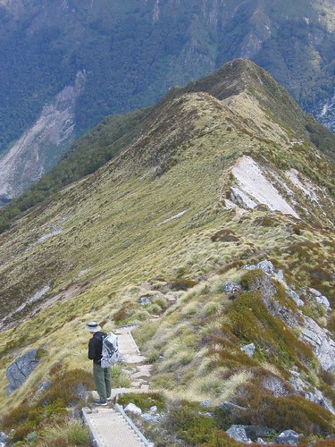
After a little rain last night, we woke to a very crisp morning, but with the bluest of skies and warm sun once we got out into it. The hike today had us climb back out of the valley briefly for a few last glimpses at the mountains, then spent the rest of the time gradually heading down through the trees to Howden Hut. From there (where Keith made the short jaunt back down the Caples track to get our tent). From there we took one more side trip up to another hill with more views, then back to the carpark. Here we are on that side track, called Key Summit contemplating the beauty of it all:
Just gorgeous. Now we wait for the bus and the four hour drive to Queenstown. (Carl and Tory....I highly recommend this hike as one for you to do if end up in NZ! I would do this one over the Kepler if you are limited on time. Much more dramatic scenery.)
Happy Thanksgiving! As I type this you all back home are enjoying cozy, turkey dinners with friends and family. I hope you are all enjoying!!
We're back from our 6 day adventure in the southland sounds and alpine areas. If you want to cruise on down to the last entry about the Kepler Track, I've put some photos up. We are in Queenstown right now - still on the southwest corner of the South Island. Queenstown is another tourist/adventure haven. We're just lying low and resting, bypassing the touristy stuff. We only have 6 days left and have decided to rent a car for those days so we can stop along the way without having to spend so much time figuring out bus schedules and how to get to the last few side trips we want to do. Being on the south part of the island is an advantage as well, because you can get nice deals on rental cars. The companies need their cars moved back up north because so many travelers travel from north to south, then fly out. Anyway, below is again my journaling of the hiking and kayaking we did. Again, it may be too boring for most. The Readers Digest version is that everything went well and was beautiful, except for one miserable day on the trail, where we got a taste of the unpredictable, at times unpleasant NZ weather that everyone keeps warning us about. So read on at your own leisure.....
Sat, November 19, 2005:
The dramatic beauty of the Milford Sound. We got to see it by kayaking rather than aboard one of the many cruise ships that make their way around the sound - or is it a fiord? The technical definition of a sound is a water filled valley that was carved out by a river. And a fiord is one that was carved out by a glacier. (Am I right dad?) The valleys of where we kayaked were carved by glaciers, so technically it should be called the Milford Fiord, right? Well, our guide today said they have compensated for this fact by naming the whole area Fiordlands National Park. Whatever the correct geological name, it was stunning. The Milford Sound is one of the only of the many sounds that line the West Coast of the southern half of the south island that is accessible to people by car. Doubtful Sound is the other one and requires a long drive, a boat ride, then another drive over a pass. The land is quite remote here. You can get to other parts of the park also by helicopter or plane, by walking some very difficult tracks, or by boat via the Tasman Sea.
Even getting to Milford is a bit of work (or time at least). From Te Anau (the last major town before the sound) it is about a 2 hour drive to Milford Sound via what is supposedly the famous Milford Road. A very long, winding and beautiful drive. We got picked up at the ungodly (for us vacationers anyway) hour of 6:30 AM by the kayak company to make the journey. The first part was nondescript, but once we started gaining elevation and after passing through Homer Tunnel, we started getting more dramatic views. Eventually we had our first view of the sound and it was a beaut. Essentially, it looks like mountains that have been submerged. Very steep, tree-covered cliffs that plunge right into the water and peaks towering high above.
The weather was marginal. Cloudy, and looking like it could rain at any time, but very calm water. We got geared up, safety talk done, then hit the water. Keith and I in a double and three other couples and our guide. We took our time circling the sound and enjoying the views. Of course Keith and I would have liked to have gone further out into the sound, but that is one of the problems with guided tours - you have to go where they tell you. On the other hand our guide was awesome and gave us lots of good information about the area. For wildlife we saw lots of penguins and one seal. We had a leisurely lunch stop, a peak at where the famous Milford Track ends, then were back to teh docks by 3:00. We never did get rained on - it got a tad bit windier, but no rain which was nice. The sandflies down here though....yikes are they bad! There's a Maori story saying that one of the gods created them to keep people away from the beauty of the area so as not to destroy it.
Here's us in the kayak:
And a view of Mitre Peak - one of the most photographed parts of the sound:
After kayaking we had a quick tour of Milford, which consists of a pub, a lodge, and a cruise boat terminal where 6,000(!) people a day take motor boat cruises around the sound. The van stopped to take in some views on the way back, and some hot drinks and biscuits (cookies), then we got dropped off at the Divide (where the mountain ranges split the east and west sides of the island). From here we started our 5 day hike.
The original plan was to just do the Routeburn Track - another Great Walk. But it is not a loop track and the logistics of getting back to where you started to pick up the rest of your stuff is a nightmare and a ton of driving. So we created our own loop track by combining the Caples Track with the Routeburn, which only involved one shuttle (and a stay in a lodge!) to get from the end of the Caples to the beginning of the Routeburn. So to start we headed up the Routeburn from the Divide for about an hour after which we turned off onto the Greenstone/Caples track. This portion was not a Great Walk so camping is free and the huts are much cheaper at only $10 per person. 20 minutes into this trail, we arrived at our campsite for the fist night. We brought our tent and sleeping pads in this far, close to where the trail divides, with the plan to stash them, stay in huts the rest of the time and pick them up on our way out.
There is one thing I think I forgot to mention about the Kepler Track and great walks in general. While you do have to pay a premium, what you get for it is almost worth it. The huts are very well set up with sleeping bunks (with nice pads), cooking facilities, drinkable water, flush toilets. What this means is you save a LOT of weight by staying in them, and packs become considerably lighter. We became quite spoiled in this way on the Kepler, so we opted for the huts the rest of the way on this walk for the weight factor as well as the unpredictable weather factor. Tents can only stay dry for so long.
So there you are, rambling as usual. We got to camp by 6:00 PM and set up the tent just as the rain started. We ate dinner, and quickly climbed in to sleep. The forecast calls for rain all day tomorrow, so we are preparing for the worst, but hoping for a break.
Sunday, November 20, 2005:
We we knew if we kept glowing about how lucky we have been with the weather it was going to come up and bite us in the ass at some point. Unfortunately the forecast was dead on. It rained ALL DAY today. Not even a pause. We got absolutely soaked. Our worst day hiking probably ever (although as I sit here typing this now, it doesn't seem like it was all that bad). I guess we couldn't come away from NZ without one hike like this. Glad it wasn't on the Routeburn where the truly spectacular views are supposed to be. It rained all night on us, and I think the guy at customs who washed our tent, washed some of the waterproofing off because by morning rain was starting to drip through. We woke up early but stayed in bed waiting for "the rain to stop". Ha. We'd still be lying there waiting!
We finally bit the bullet, donned all the raingear we had (of which Keith has very little). I just bought some waterproof pants, and boy am I glad I did. We packed up quickly, stashed the tent and off we went. Given the pounding rain, gusty wind, and knowledge that we had to go up and cross over a saddle, I sort of wanted to go on the other track that follows another river (but would entail more mileage). However, since we forgot the maps (just what our parents want to hear - lacking in raingear, alpine crossings and no map) we didn't know if we'd make our bus on the other side, so we stuck with the original plan. We quickly learned the defnition of Great Walks (of which this isn't). Great Walk = great track, great track maintenance, great signage, and great huts. This trail sucked. Very narrow, steep, and completely root laden. Anyone who has hiked at all, knows how slippery a wet root can be. That is all we've been walking on is roots. We did OK the first hour dealing with it all. As we got closer to treeline, I started to break down (I think I was literally whimpering there for a second).
Then we broke treeline and yes, the wind was fierce and the rain harder and colder. But Keith assured me we wouldn't be up there long and the trail had miraculously become easy walking. So we booked it, finally being able to walk faster and our spirits a little lighter (this is 2.5 hours from the start). Then we started heading back down into the valley on the other side and lo-and-behold the trail begain to deteriorate again. They did have good markings on the trees so we were never in danger of losing the trail, it was just really hard walking. At this point Keith's jacket is starting to soak through and my waterproof shoes are no longer waterproof. At about 3 hours from start, and know Keith is having a little breakdown as he is pretty much soaked from head to foot. We are both tired and the rain shows no sign of letting up. I have got to hand it to the polypro/fleece/wool gear - you do stay warm, even when wet. Moving helps of course as well. I thought my hands would be goners buy I kept my saturated fleece gloves on and they (my hands) stayed warm the whole time.
Eventually, we both stopped complaining and buckled down and dealt with the misery of it and had as much fun with it as we could. With less trail maintenance comes river crossings with no bridges and that pretty much sealed the deal for wet feet. That and the fact that our trail was a river itself half the time. Keith only managed to fall once due to a faulty boardwalk, Em three times. We stopped once to use the loo, otherwise we motored on through to the hut arriving at about 2:30 (5 hours of walking in the rain). What a beautiful sight it was. There was one other guy there and he already had a fire going. Upon changing into dry clothes (the garbage bags worked like a charm) we both realized just how wet we were. We got things hung up to dry and are now settled in quite snugly to this humble hut (Upper Caples Hut). It is a smaller hut but has all the same amenitites except for gas cookers and a flush toilet. Anything with a roof and a fire is fine with me at this point.
Here's Keith monitoring the drying of the clothes in the Upper Caples Hut:
Monday, Nov 21, 2005:
The rain finally quit late in the evening last night and we got some nice views of the cliffs surrounding us. Keith managed to get a decent size coal fire stoked upa nd it seemed as if our stuff just might dry. Another gal joined us, arriving late, and just as wet. A very pleasant evening was spent in what was a much cozier hut than the big guns on the Great Walks. We slept well, woken only by the frequent and loud rain showers, but were pleased to wake to no rain. The skies weren't clear, but they were much less angry than yesterday giving us hope for a dry walk out. Regardless - we would have been more tolerant of rain as at the end of the day we have a room booked at what people have been calling the cozy and quaint, lovely Kinloch Lodge.
As it turned out, we barely got drizzled on and had a very nice, easy hike out. Teh walk was mostly out of the woods in a wide open very pretty valley following right along the Caples River. Even though the trail was quite easy walking, we were both quite tired - physically and emotionally wiped from teh day before is all we could figure. Lovely scenery the entire way (except for teh dead cow right on the trail!) and we were at the trailhead/carpark with a half hour to spare before our shuttle arrived. Teh shuttle turned out to be a boat ride that dropped us in Kinloch which amount to the lodge and two houses.
Kinloch lodge is a great place. They have a whole range of accomodations from deluxe, all inclusive to backpacker/hostel style. We stayed in our usual double room with shared facilities, butthe rooms are much nicer than any hostel we've stayed at yet. There is an onsite restaurant, all the usual facilities (TV room, kitchen, living space), but the best part (and most needed) was the hot tub! Ahhhhh!!!!
The wind was amazingly strong all night and quite cold which had me a bit worried about our high elevation hike. We'll see what tomorrow brings, in the meantime we're making the most of these facilities - which includes getting our stinky clothes freshened up again.
Tuesday, Nov 22, 2005:
We awoke thi smorning to clear, blue skies and calm air. Yay! We got all checked out an dafter splurging on a cup of coffee were off in another shuttle headed to the Routburn trailhead. We started our hike at about 10:15 and could already tell it was going to be a much more crowded trail than any other so far. But if the mountains we saw on our drive to the trailhead were any indication, we could also tell it was likely going to be even more scenic than any others as well.
The climb up here to Routeburn Falls Hut was relatively easy, taking only about 3 hours and was absolutely stunning (the clear day helped of course). Valleys and waterfalls, turquoise rivers, and snowcapped rugged mountains teh whole way. There are lots of guided walks on this trail, so we passed many large groups moving quite slowly. There is also an option to walk the entire track guided and stay in private huts along the way....for a measly $1200. Apparently you get fancy meals cooked for you and I'm assuming much warmer and more pleasant sleeping quarters than un independent walkers get.
This hut sits right on a fairly steep cliff just below Routeburn Falls and overlooking the valley from whence we came - in other words great views to read your book and sip your hot chocolate by. We got here so early that after claiming our bunks, we walked up the trail a bit further to catch some more views just in case teh weather turns on us tomorrow and blocks it all. Forecast for tomorrow is confusing, but calling for some not-so-nice stuff. We'll see.
Wed & Thurs, Nov 23 & 24, 2005:
I write this from the parking lot - the beginning and end of the Routeburn Track and our major tramping in NZ. We ended with a fabulous 2 days of hiking . Yesterday's forecast was quite glum - lots of nasty talk about southwesterlies blowing in and rain easing off to showers by the afternoon. The skies were clear when we woke up, so we headed off quickly wanting to get to the top of Conical Hill (a side trip that offers spectacular 360 views) before these southwesterlies moved in. We lucked out again. It was a cloudy day, but the clouds stayed high enough that we still got all those great views. Check out us on top of Conical Hill:
And the rain didn't come until we were well settled into our hut at McKenzie Lake. When the weather is fine and the hiking is superb, there isn't much to say. This truly was teh most stunning hike we did and a great one to end on. Yesterday's walk took us climbing out of the waterfall-laden basin where our first hut sat to the ridge that overlooked teh Hollyford Valley and lots of dramatic, steep snow capped mountains. The rest of the day followed along that ridge for about 8 km until dropping back down to McKenzie Lake and our hut. The walking has been relatively easy and we've been getting to the huts or carparks by about 2:00 with leisurely breakfasts and lunch stops. Pretty nice - almost need the hiking days to be a bit longer.
After a little rain last night, we woke to a very crisp morning, but with the bluest of skies and warm sun once we got out into it. The hike today had us climb back out of the valley briefly for a few last glimpses at the mountains, then spent the rest of the time gradually heading down through the trees to Howden Hut. From there (where Keith made the short jaunt back down the Caples track to get our tent). From there we took one more side trip up to another hill with more views, then back to the carpark. Here we are on that side track, called Key Summit contemplating the beauty of it all:
Just gorgeous. Now we wait for the bus and the four hour drive to Queenstown. (Carl and Tory....I highly recommend this hike as one for you to do if end up in NZ! I would do this one over the Kepler if you are limited on time. Much more dramatic scenery.)
Thursday, November 17, 2005
The Kepler Track....in excruciating detail
Still in Te Anau. We've taken the last two days "off", and gearing up for a 5 day extravaganza of kayaking and hiking. So you won't hear from us for about a week after we get to our next major city which will be Queenstown....the bungy capital of the world apparently.
OK, here is the journalling I did while we hiked on the Kepler Track. Feel free to not read this, as it won't be too exciting - nothing life shattering or out of the ordinary happened to us, but it might give you a feel of a typical Great Walk experience in NZ if you are curious. And, no I won't be able to get any pictures up until our next major city. No USB ports available for use here. Sorry...
Sunday, 13-Nov-05
We left our hostel at about 9:00 to start the 60km Kepler Track. This is a loop track and you can access it directly from town - which means no expensive shuttle! Yay! We of course had to stop for coffee, so official start time on the trail was 9:30. Te Anau sits right on Lake Te Anau (thus the name) and to get to the formal trail head you have to walk quite a ways around the lake. This took about an hour and was easy and scenic. A sculler rowed by on the calm water with snow capped peaks in the background. Very nice. Once we hit the formal trailhead we continued to follow the lake, but now through beech forest. After about an hour, we branched off and headed up. This is where we also encountered our first fellow trampers. What we quickly realized is this would be the same group of people we would be seeing a lot of as there is only one option of where to sleep each night (unless you want to walk an absurd amount of miles). This track has three huts all spaced about 6 hours apart from each other, and they don't allow camping at any of them, so we were forced to pay the big bucks of $40 per person per night. As it turns out this was a blessing in disguise. Being one of the ten Great Walks of New Zealand, the huts are quite well equipped, and the tracks very well maintained, thus the bigger expense - and we were glad for this as the first night was a cold one.
So up the hill we headed, making quite nice time and staying ahead of the pack of people behind us. The weather was nice for the first half of the day - partly cloudy and a comfortable temperature. Just before breaking treeline, however, it started to rain. And a cold hard rain at that. Luckily we had only about a half hour to go to get to the hut (this is where I was saying, thank goodness we had to stay in a hut!). All of our gear was good in teh rain except our pants, where soaked through immediately. Which will be OK in the tropics but not up in high alpine areas. At any rate, we got to the hut, Luxmore Hut, which had great views of Lake Te Anau and the mountains when the clouds moved out of the way. The hut was big - sleeping 55 people, and with a large kitchen area and gas cookers and water provided as well as a wood stove. The bunk rooms themselves are not warm at all, and so everyone spent the majority of the evening huddled in the big living area reading books, playing cards and visiting. There was about 20 of us in total.
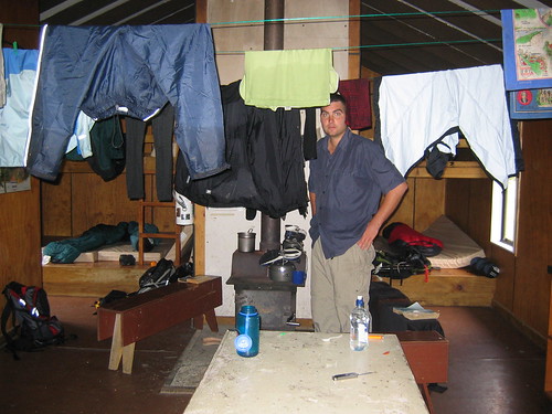
Here's a look at the first hut we stayed at on that rainy evening:
After warming up with some hot chocolate, we went out again to explore a nearby cave. Nothing spectacular about the cave, just that it was a bit of an adventure to walk through. It had a sizable stream running through it and some tight squeezes to get through, but no dramatic stalactites or mites. We only went in about 1/4 of a mile because we didn't want to get totally wet and dirty from climbing around on the ground through the tighter spots. Went back to the hut then, and made dinner, played cards with some fellow hikers, and turned in for what was a restless nights sleep. We both ended up sleeping in every article of clothing we brought and never quite got warm.
OK, here is the journalling I did while we hiked on the Kepler Track. Feel free to not read this, as it won't be too exciting - nothing life shattering or out of the ordinary happened to us, but it might give you a feel of a typical Great Walk experience in NZ if you are curious. And, no I won't be able to get any pictures up until our next major city. No USB ports available for use here. Sorry...
Sunday, 13-Nov-05
We left our hostel at about 9:00 to start the 60km Kepler Track. This is a loop track and you can access it directly from town - which means no expensive shuttle! Yay! We of course had to stop for coffee, so official start time on the trail was 9:30. Te Anau sits right on Lake Te Anau (thus the name) and to get to the formal trail head you have to walk quite a ways around the lake. This took about an hour and was easy and scenic. A sculler rowed by on the calm water with snow capped peaks in the background. Very nice. Once we hit the formal trailhead we continued to follow the lake, but now through beech forest. After about an hour, we branched off and headed up. This is where we also encountered our first fellow trampers. What we quickly realized is this would be the same group of people we would be seeing a lot of as there is only one option of where to sleep each night (unless you want to walk an absurd amount of miles). This track has three huts all spaced about 6 hours apart from each other, and they don't allow camping at any of them, so we were forced to pay the big bucks of $40 per person per night. As it turns out this was a blessing in disguise. Being one of the ten Great Walks of New Zealand, the huts are quite well equipped, and the tracks very well maintained, thus the bigger expense - and we were glad for this as the first night was a cold one.
So up the hill we headed, making quite nice time and staying ahead of the pack of people behind us. The weather was nice for the first half of the day - partly cloudy and a comfortable temperature. Just before breaking treeline, however, it started to rain. And a cold hard rain at that. Luckily we had only about a half hour to go to get to the hut (this is where I was saying, thank goodness we had to stay in a hut!). All of our gear was good in teh rain except our pants, where soaked through immediately. Which will be OK in the tropics but not up in high alpine areas. At any rate, we got to the hut, Luxmore Hut, which had great views of Lake Te Anau and the mountains when the clouds moved out of the way. The hut was big - sleeping 55 people, and with a large kitchen area and gas cookers and water provided as well as a wood stove. The bunk rooms themselves are not warm at all, and so everyone spent the majority of the evening huddled in the big living area reading books, playing cards and visiting. There was about 20 of us in total.
Here's a look at the first hut we stayed at on that rainy evening:
After warming up with some hot chocolate, we went out again to explore a nearby cave. Nothing spectacular about the cave, just that it was a bit of an adventure to walk through. It had a sizable stream running through it and some tight squeezes to get through, but no dramatic stalactites or mites. We only went in about 1/4 of a mile because we didn't want to get totally wet and dirty from climbing around on the ground through the tighter spots. Went back to the hut then, and made dinner, played cards with some fellow hikers, and turned in for what was a restless nights sleep. We both ended up sleeping in every article of clothing we brought and never quite got warm.
Monday, Nov-14-05
We were in no hurry to get up this morning. It was much warmer this morning downstairs in the living area as the sun was streaming in. Yay! Sun! After listening to and watching the rain last night it was great to see the sun and partially clear skies this morning, as this was to be the most scenic day of the hike. The forecast looked good (there is a ranger stationed at each hut and they provide the day's weather forecast each morning at 8:30). Although the entire forecast things is funny here. NZ has proved to be more unpredictable in terms of weather than the Pacific NW. Regardless, everyone in the hut, huddles around the board and reads it like it were the Gospel - I guess any sense of hope of a nice day helps the morale. It is just so rarely correct, and changes so drastically each day, it is almost a wonder we bother to look at all.
After all that, the forecast was right on for the day. We had lovely weather (which really just means no rain). It was cloudy most of the day, but not enough to block our views. The whole walk today was up in the alpine region and followed several ridges providing breathtaking view after breathtaking view of the fiords of Lake Te Anau and all the surrounding mountains. We took our time knowing the weather was good, and that we had plenty of time (the 6 hours between huts is very conservative hiking time). So we went up every side track, took lots of long breaks and still made it down to the next hut (Iris Burn Hut) by 4:00.
Here are two shots of the ridge lines we walked on and views from the ridgeline: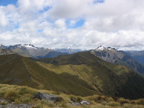
This hut sits closer to the valley floor, at a much lower elevation than the previous night, so it was much warmer. Although with the lower elevation, comes the infamous NZ biting sandflies (of which we were unprepared to deal with on the Abel Tasman hike). Plenty of DEET this time, and we had the hut to escape from them in. Another relaxing evening of book reading and eating. Although we realized we were too scimpy on our food this hike, and had to eat very slowly and relish every bite. We might actually shed a few pounds on this one....shocking.
Tuesday, 15-Nov-05
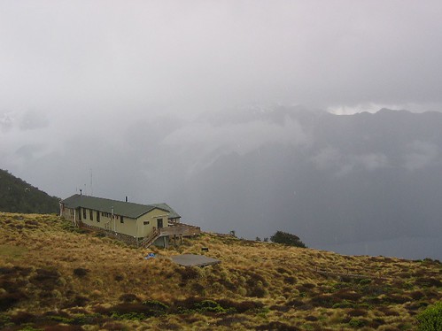
Very easy walk today. The forecast called for afternoon showers, so we got up early and walked relatively fast to avoid them. Of course they never showed up. The walk was just down the river valley, so it was quite flat and pleasant. We came up to Lake Manapouri, then headed back north towards Te Anau to complete the loop. We arrived at the hut early (at 2:00), and really got lots of relaxing in. Keith even took a nap. Can't believe how much we have been sleeping lately! This hut sits right on Lake Manapouri and has absolutely gorgeous views.
Wednesday, 16-Nov-05
Hiking out today. Another very flat and easy walk.
Here's a look at the beech forest that we spent many an hour walking through on our way out: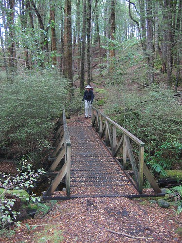
You have the option of stopping early and catching a shuttle back to town, but we walked the whole thing following another river, and made it back to town by 1:30, ready for a hot shower and a big meal. Great hike.
Tuesday, November 15, 2005
The Kepler Track
Hey all. This will be a short post. Just wanted to provide a quick update. We are currently in Te Anau, NZ, which is on the west coast, southern part. Very near the famous Milford Sound. We just got back from a four day tramp on the Kepler Track. Very pretty. Lots of alpine views, views of the fiords, pretty forest walking and our first stays in the Great Walks' huts. We didn't have the option to camp this time and were forced to shell out the $40 per person per night at each hut. A blessing in disguise though, as the first hut was quite high up and quite cold and rainy that first night. I would have been quite grumpy in the tent. After that we really lucked out on the weather and had a clear day for the most important day which was over the pass with all the views. We're taking the day off tomorrow, so maybe I'll copy the journalling I did onto the website if anyone is interested in the minutae of the hike. I'd like to get pictures up of it, but the internet in this town is fairly restrictive and expensive, so we'll see. It might have to wait until we get to Queenstown. For now our plans are to kayak the Milford Sound and do one more big hike. Only two weeks left in NZ. Amazing!
Hope all is well back home!
Hope all is well back home!
Thursday, November 10, 2005
Biking in Dunedin
10-Nov-05
We arrived to our Dunedin hostel late, and were treated with a free upgrade as the place was somewhat empty, and the owner "hated to see it go empty". It is just a bigger room with a skylight and a TV, for the price of the standard double, but, hey we'll take it! Nicely equipped hostel by the way. Quite an old building, but nice amenities like this computer I am typing on now. Not hooked up to the internet, but free to use to look at photos and type blog entries that can be saved to memory stick and cut and pasted to blog later! (Nice!) We slept well, and headed out this morning to the information center to see what to do with ourselves in this town. Driving into the town yesterday, I was quite impressed with what I saw. Very nice first impressions of the city. Lots of very old, Victorian style buildings, a bustling, yet not overly crowded downtown, and quite hilly with views of the bay. And the service so far has been very nice - free upgrade at the hostel, bus drop off service at the doorstep, and free coffee at the bike shop!
So yeah, we ended up at a bike shop, rented ourselves some mountain bikes (after indulging in a free 'flat white' cooked up on the bike shop's very professional espresso machine), and headed out on what turned out to be an epic, tortuous, rewarding, and fun(?) bike ride. The Otaga Peninsula stretches out East of Dunedin and houses one of only two nesting grounds for the great and endangered Northern Royal Albatross. For those who don't really know what an Albatross is (it's OK, I was having memory blocks as well), it is a very large bird. Huge bird. And quite interesting. They mate every other year, and spend most of their lives literally flying around the world, only resting every other year, in the same place. The colony on the end of this penninsula is one of only two in the world for this particular type. They can fly for up to 1000 km a day, and at speeds of up to 100 km/h. They are very large and heavy birds so they maximize the use of the wind currents to minimize the amount of energy the expend.
Anyway, we thought a fun way to get out there would be to ride bikes, since all we've been doing is walking everywhere, we thought it would be a welcome change. And it was, but as usual, we overextended ourselves, and are quite beat up and exhausted this evening. Keith figures we probably ended up riding about 60 miles today. Yikes! We made it out to the end (28km) with no problem and although the viewing area to the Albatross was closed due to hanky panky of the birds, we were fortunate enough to spot one flying in the air over our heads. Before knowing much about the birds, we weren't sure we'd recognize one when we saw it as there are so many other birds flying around (mostly seagulls), but when we saw it, there was no question because it was enormous and dwarfed all the other birds around it. Very cool. No picture, sorry, I was too busy watching it.
Then we got ambitious on our bikes. On the ride out we followed the coastal rode, which was pretty much flat the whole way. For the ride back, we thought we'd first detour and see another beach on the other side that might have some yellow-eyed penguins, then take the high road back. Fine idea, but it added a lot of distance and a whole lot of uphill to the ride. I suppose we were rewarded by all the climbing with a nice long continuous downhill ride, but by that time it was hard to enjoy it as sitting on the bike was quite painful at that point. Long story short, we did it all, (and enjoyed most of it) but by the end we were sore all over (back, knees, butt, neck, hands) and just happy to be back. Needless to say, tomorrow is a take it easy, wander around town kind of day.
Hope all is well back home!
Lots of love,
Em and Keith
We arrived to our Dunedin hostel late, and were treated with a free upgrade as the place was somewhat empty, and the owner "hated to see it go empty". It is just a bigger room with a skylight and a TV, for the price of the standard double, but, hey we'll take it! Nicely equipped hostel by the way. Quite an old building, but nice amenities like this computer I am typing on now. Not hooked up to the internet, but free to use to look at photos and type blog entries that can be saved to memory stick and cut and pasted to blog later! (Nice!) We slept well, and headed out this morning to the information center to see what to do with ourselves in this town. Driving into the town yesterday, I was quite impressed with what I saw. Very nice first impressions of the city. Lots of very old, Victorian style buildings, a bustling, yet not overly crowded downtown, and quite hilly with views of the bay. And the service so far has been very nice - free upgrade at the hostel, bus drop off service at the doorstep, and free coffee at the bike shop!
So yeah, we ended up at a bike shop, rented ourselves some mountain bikes (after indulging in a free 'flat white' cooked up on the bike shop's very professional espresso machine), and headed out on what turned out to be an epic, tortuous, rewarding, and fun(?) bike ride. The Otaga Peninsula stretches out East of Dunedin and houses one of only two nesting grounds for the great and endangered Northern Royal Albatross. For those who don't really know what an Albatross is (it's OK, I was having memory blocks as well), it is a very large bird. Huge bird. And quite interesting. They mate every other year, and spend most of their lives literally flying around the world, only resting every other year, in the same place. The colony on the end of this penninsula is one of only two in the world for this particular type. They can fly for up to 1000 km a day, and at speeds of up to 100 km/h. They are very large and heavy birds so they maximize the use of the wind currents to minimize the amount of energy the expend.
Anyway, we thought a fun way to get out there would be to ride bikes, since all we've been doing is walking everywhere, we thought it would be a welcome change. And it was, but as usual, we overextended ourselves, and are quite beat up and exhausted this evening. Keith figures we probably ended up riding about 60 miles today. Yikes! We made it out to the end (28km) with no problem and although the viewing area to the Albatross was closed due to hanky panky of the birds, we were fortunate enough to spot one flying in the air over our heads. Before knowing much about the birds, we weren't sure we'd recognize one when we saw it as there are so many other birds flying around (mostly seagulls), but when we saw it, there was no question because it was enormous and dwarfed all the other birds around it. Very cool. No picture, sorry, I was too busy watching it.
Then we got ambitious on our bikes. On the ride out we followed the coastal rode, which was pretty much flat the whole way. For the ride back, we thought we'd first detour and see another beach on the other side that might have some yellow-eyed penguins, then take the high road back. Fine idea, but it added a lot of distance and a whole lot of uphill to the ride. I suppose we were rewarded by all the climbing with a nice long continuous downhill ride, but by that time it was hard to enjoy it as sitting on the bike was quite painful at that point. Long story short, we did it all, (and enjoyed most of it) but by the end we were sore all over (back, knees, butt, neck, hands) and just happy to be back. Needless to say, tomorrow is a take it easy, wander around town kind of day.
Here is me at what I am hoping is the top of the hill (trust me the smile is forced at this point). See the water way down there? That shows you how high and relentless the climb was.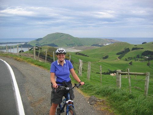
And some random photos. Remember I said how NZ public places are generally not dog friendly? What do you think gave me that idea? First time I saw one of these signs, I couldn't figure it out. But after seeing my umpteenth sheep field, I figured out that dogs are probably shot in interest of preserving the sheep....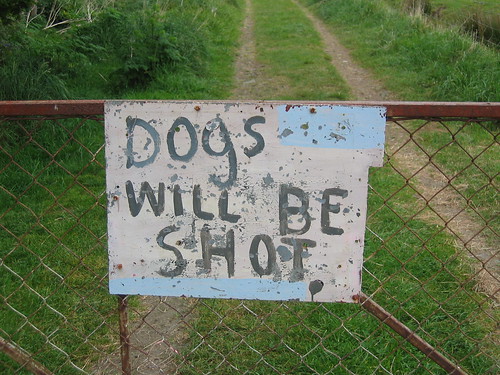
And the railway station in Dunedin. One of the many ornate and interesting buildings here.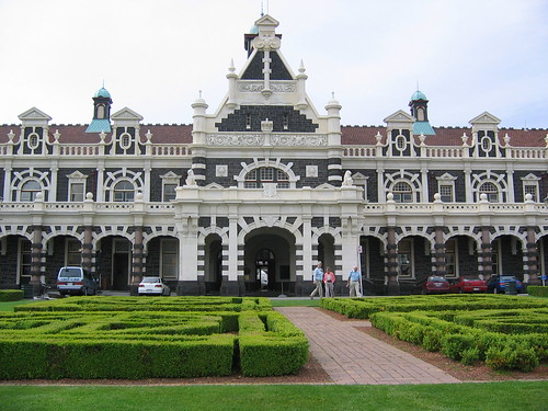
Hope all is well back home!
Lots of love,
Em and Keith
Finishing up in Christchurch (for now)
8-Nov-05
While Jenn and I were fooling around in the internet cafe and writing our lengthy catch up travel updates, the boys spent the rest of the day at the racetracks. This particular day was a big one for Christchurch, Cup Day. A big horse racing day. So they wanted to go catch part of it after our exploration at Akaroa. It was horse racing, but the harness kind, where the horse is rigged up to harness and the jockey rides a cart (for lack of better word, not knowing the correct term) which the horse pulls. Keith will have to fill in with more details, but they had a good time and Keith got lucky on the last race and broke even for the day.
While that was going on, Jenn and I walked around Christchurch a bit more and explored the botanical gardens. They have a huge garden there, and we only touched the surface of it. Then we ventured onto the city bus system to catch a ride back to Sumner (the beach house), and I personally was quite impressed with the bus system. The main terminal is run a lot like a subway system, and they make it very hard to miss your bus if you pay attention. So home without any difficulty, but a bit later than planned only to be surprised with dinner on the way from the men and a surprise dessert of NZ pavlova for an early birthday celebration for Jenn.
9-Nov-05
Our last day in Christchurch (for now), and the day we have to say goodbye to our good friends for a long while. Jenn and John have one more night and a late flight on the 10th to go back home and we decided to head on out to Dunedin (about 4 hours south from Christchurch, still on the east coast). So we spent the morning packing, me taking some of Jenn's travel goodies, Jenn loading us up with leftover food, and a leisurely walk on the beaches of Sumner. Then it was off to the city centre where we watched the infamous Wizard do part of his daily lecture (a colorful character who has been coming to the city square for years and delivering random speeches every day at 1:00). He was talking something about the right way to keep a woman, and Jenn and I quickly got bored and roamed the craft fair going on, and got me some more fashionable (albeit, cheap) sunglasses. Then it was goodbye and off to the bus.
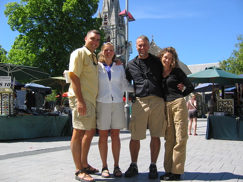
Here is a shot of the four of us in cathedral square in Christchurch. Basically the center of town:
While Jenn and I were fooling around in the internet cafe and writing our lengthy catch up travel updates, the boys spent the rest of the day at the racetracks. This particular day was a big one for Christchurch, Cup Day. A big horse racing day. So they wanted to go catch part of it after our exploration at Akaroa. It was horse racing, but the harness kind, where the horse is rigged up to harness and the jockey rides a cart (for lack of better word, not knowing the correct term) which the horse pulls. Keith will have to fill in with more details, but they had a good time and Keith got lucky on the last race and broke even for the day.
While that was going on, Jenn and I walked around Christchurch a bit more and explored the botanical gardens. They have a huge garden there, and we only touched the surface of it. Then we ventured onto the city bus system to catch a ride back to Sumner (the beach house), and I personally was quite impressed with the bus system. The main terminal is run a lot like a subway system, and they make it very hard to miss your bus if you pay attention. So home without any difficulty, but a bit later than planned only to be surprised with dinner on the way from the men and a surprise dessert of NZ pavlova for an early birthday celebration for Jenn.
9-Nov-05
Our last day in Christchurch (for now), and the day we have to say goodbye to our good friends for a long while. Jenn and John have one more night and a late flight on the 10th to go back home and we decided to head on out to Dunedin (about 4 hours south from Christchurch, still on the east coast). So we spent the morning packing, me taking some of Jenn's travel goodies, Jenn loading us up with leftover food, and a leisurely walk on the beaches of Sumner. Then it was off to the city centre where we watched the infamous Wizard do part of his daily lecture (a colorful character who has been coming to the city square for years and delivering random speeches every day at 1:00). He was talking something about the right way to keep a woman, and Jenn and I quickly got bored and roamed the craft fair going on, and got me some more fashionable (albeit, cheap) sunglasses. Then it was goodbye and off to the bus.
Here is a shot of the four of us in cathedral square in Christchurch. Basically the center of town:
We had a wonderful time hanging out with you guys, John and Jenn! It was so fun getting to know you better and spend some nice, relaxing time exploring part of NZ together. We look forward to more adventures together!
Monday, November 07, 2005
Last Day in Christchurch
November 8, 2005
I have to speed things up here, because Jenn is getting tired of waiting for me.
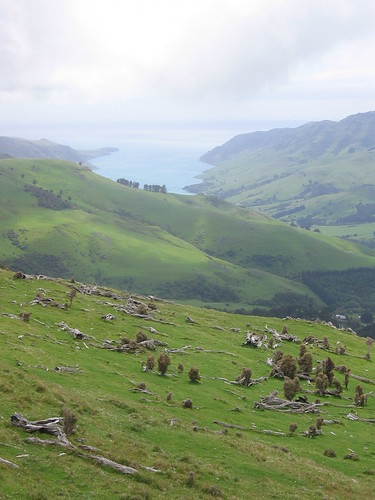
Today we drove down to the end of Banks Peninsula to see the charming French town of Akaroa. We actually didn't make it all the way into town, but saw nice views of it from ahigh (?). We took a nice walk through the trees and up on to the rolling hills overlooking the harbor and the town.
A foggy, cooler day today, which was a relief as our hike was a bit of a steep hill.
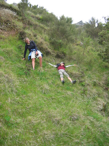
Not wanting to go back the way we came, we made a loop of our hike, crossing through some pastures, scaling barb-wired fences, scaring sheep, and playing with cows. It all went off without a hitch until we had to go down the steep embankment to the road, where Jenn ran into a bit of difficulty on the slippery grass:
We will part with our dear friends tomorrow as we continue south to Dunedin tomorrow.
Hope all is well with everyone at home! Our thoughts are with you all!!
I have to speed things up here, because Jenn is getting tired of waiting for me.
Today we drove down to the end of Banks Peninsula to see the charming French town of Akaroa. We actually didn't make it all the way into town, but saw nice views of it from ahigh (?). We took a nice walk through the trees and up on to the rolling hills overlooking the harbor and the town.
A foggy, cooler day today, which was a relief as our hike was a bit of a steep hill.
Not wanting to go back the way we came, we made a loop of our hike, crossing through some pastures, scaling barb-wired fences, scaring sheep, and playing with cows. It all went off without a hitch until we had to go down the steep embankment to the road, where Jenn ran into a bit of difficulty on the slippery grass:
We will part with our dear friends tomorrow as we continue south to Dunedin tomorrow.
Hope all is well with everyone at home! Our thoughts are with you all!!
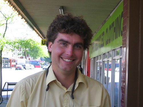
Pretty Boy?
For those faithful readers of this website, you may remember a post about shaving Gracie in the summer time, with a nice before and after shot. Well now I get to do the same for my husband.
Here is Keith yesterday at about 4:00 PM:
(I see now this is a bad picture because you can't see the extent of the poofiness of his hair)
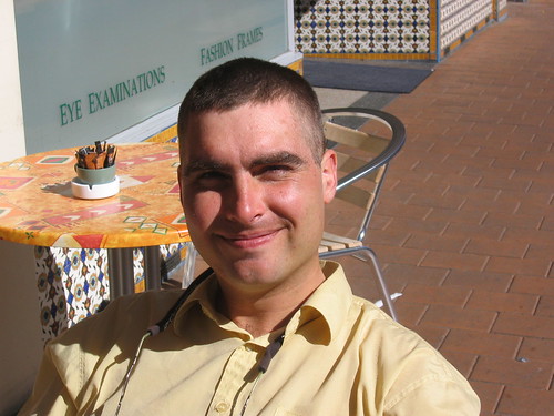
Five dollars and five minutes later, here he is:
Here is Keith yesterday at about 4:00 PM:
(I see now this is a bad picture because you can't see the extent of the poofiness of his hair)
Five dollars and five minutes later, here he is:
On to Christchurch....with Friends!!
Happy with a successful first hike, we recovered with a night in Picton, and met John and Jenn the next morning (November 4th) and headed south down the East coast towards Christchurch - the largest city on the South Island, and freqently a gateway to Antarctica. John and Jenn are good friends of ours from Eugene who recently got married (in Kauai!) and are in NZ for the final stage of their 8-week, round the world, extravaganza honeymoon. We were so excited to hear they would be here the same time as us, so we made sure to spend some time together. With no specific plans in mind we had a nice leisurely drive south through Kaikora, which is described as where the city meets the sea. And this is the truth. We got our first glimpse of what looks like a snow capped mountain spilling into the ocean. Driving down Hwy 1, you look right and see mountains, and look left and see the sea. Pretty cool.
Arriving in Christchurch, we went to check into our vacation rental that John and Jenn so graciously booked and set up for us. A welcome break from the hostel. Not that the hostels are bad, it has just been a nice change. That night after settling into the house, Jenn and I went grocery shopping while John and Keith went to investigate the local pub. The house is located in a suburb of Christchurch called Sumner, so we were really about 30 minutes from downtown. We cooked up a fine dinner, and spent the evening relaxing and visiting.
The next day we were after a hike, and had gotten some recommendations about some hikes close by. So off we went. And the weather was fabulous. Hot and bright blue skies. So off we went. Sumner sits on the beginning of the Banks Peninsula, and the hike we did wrapped around some of the coves making up that peninsula. Beautiful scenery as usual (I need to come up with some more adjectives...), but the heat caught up with us after four hours, and we returned a bit dusty and beat.
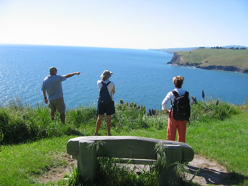
Here's a shot of us at the very beginning with John pointing the way:
After cleaning up we treated ourselves to a beer at "Keith and John's Pub". We're sitting there, enjoying a refreshing local brew, and it walks this perky, happy, bubbly, cute, curly haired gal, who locks eyes with John and Keith and says, "Hey guys!", like they were the best of friends, after which both promptly turned beet red. Remember....Keith and John went to this pub while Jenn and I were shopping and cooking for them!! So you can only imagine the amount of ribbing and teasing that took place after that (and continues every once in a while to this day).
After that, Jenn and John introduced us to our first taste of Indian food (delicious)! And then early to bed as we were all beat.
Brings us to Sunday, November 6. John was also meeting up with a good friend of his, Emily, who has relocated to NZ and is a bad ass adventure racer, and entrepreneur now here in NZ. She has started her own company and makes nutritional "cookies". You can check her out at www.powercookies.com
So we headed inland to spend time with her and her family at the small mountain town of Hanmer Springs, where there is lots of hot springs. A pleasant time had by all soaking, visiting and eating, then back to Christchurch on Monday. Through all of the contacts I have made orginating with our neighbors in Lebanon, I stumbled into a meeting with a nurse recruiter who also specializes in immigration stuff. So Jenn and I went on Monday to talk with her for a while and got lots of valuable information about what it takes to work as a nurse here, short term or long. Something we are both interested in and something we will both chew on for the next year or so.
We ended the day with a bottle of wine and more food - we have become quite good at keeping ourselves well hydrated and fed!
Cheers!
Arriving in Christchurch, we went to check into our vacation rental that John and Jenn so graciously booked and set up for us. A welcome break from the hostel. Not that the hostels are bad, it has just been a nice change. That night after settling into the house, Jenn and I went grocery shopping while John and Keith went to investigate the local pub. The house is located in a suburb of Christchurch called Sumner, so we were really about 30 minutes from downtown. We cooked up a fine dinner, and spent the evening relaxing and visiting.
The next day we were after a hike, and had gotten some recommendations about some hikes close by. So off we went. And the weather was fabulous. Hot and bright blue skies. So off we went. Sumner sits on the beginning of the Banks Peninsula, and the hike we did wrapped around some of the coves making up that peninsula. Beautiful scenery as usual (I need to come up with some more adjectives...), but the heat caught up with us after four hours, and we returned a bit dusty and beat.
Here's a shot of us at the very beginning with John pointing the way:
After cleaning up we treated ourselves to a beer at "Keith and John's Pub". We're sitting there, enjoying a refreshing local brew, and it walks this perky, happy, bubbly, cute, curly haired gal, who locks eyes with John and Keith and says, "Hey guys!", like they were the best of friends, after which both promptly turned beet red. Remember....Keith and John went to this pub while Jenn and I were shopping and cooking for them!! So you can only imagine the amount of ribbing and teasing that took place after that (and continues every once in a while to this day).
After that, Jenn and John introduced us to our first taste of Indian food (delicious)! And then early to bed as we were all beat.
Brings us to Sunday, November 6. John was also meeting up with a good friend of his, Emily, who has relocated to NZ and is a bad ass adventure racer, and entrepreneur now here in NZ. She has started her own company and makes nutritional "cookies". You can check her out at www.powercookies.com
So we headed inland to spend time with her and her family at the small mountain town of Hanmer Springs, where there is lots of hot springs. A pleasant time had by all soaking, visiting and eating, then back to Christchurch on Monday. Through all of the contacts I have made orginating with our neighbors in Lebanon, I stumbled into a meeting with a nurse recruiter who also specializes in immigration stuff. So Jenn and I went on Monday to talk with her for a while and got lots of valuable information about what it takes to work as a nurse here, short term or long. Something we are both interested in and something we will both chew on for the next year or so.
We ended the day with a bottle of wine and more food - we have become quite good at keeping ourselves well hydrated and fed!
Cheers!
The Abel Tasman Coastal Track
We got off the ferry in a charming bay town of Picton. Not many people stay in Picton, but head out to the bigger town of Nelson (west of Picton) which serves as a gateway to the many activities of the area (mostly hiking and kayaking). We did not book a bus ride ahead, and upon getting off the ferry and noting the hoards of people (we had no idea the ferry would be so big), we quickly learned that the main busline to where we wanted to go was full. Normally we'd take this in stride, as we have nothing but time. But this is the one leg of our trip that we were on a time crunch as we were getting picked up by our friends in 4 days time. Regardless we found another smaller busline that had vacancy, but then we realized we didn't have cash, and the bus was leaving in 15 minutes. So we walked to the nearest cash machine, but it was out of order. Then we tried to get info on where banks and other cash machines were and found out it was a public holiday. Long story short, Keith had to sprint to the other end of town to find a working machine, while I made sure the bus didn't leave without us. Minor hang up, but it all worked out, and off we went to Motueka, a smaller town farther east of Nelson, and closer to our tramp (hike).
We checked into another lovely hostel, and got some invaluable information about the trail from the Info center and worked out our transportation for the next few days. We stumbled upon another great deal and were able to get a free rental car for our transport back out of Motueka (after the hike) and to Picton where we were meeting John and Jenn. A pathetic car, really - like a Geo, but free is free (someone ditched a rental in Motueka and the company needed someone to drive it back to Picton).
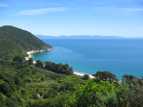
That was a bunch of nonsense really, I suppose the hike was more interesting than all of that jibber jabber. Adn a lovely hike it was. 51 km total, hiked over 3 days, 2 nights. The weather was great. Sunny and hot the first day, cloudy and cool the second, and somewhere in between on the third. It never did rain however. As the name implies it is a Coastal track, so it follows the coastline af the Abel Tasman National Park which sits on the East side of the northern most peninsula of the north island. The best way I can describe the scenery and climate is to say it is a combination of Hawaii and the Pacific Northwest. The scenery looks like Hawaii - white sand pristine beaches and bright blue water, surrounded by subtropical forests; but the temperature of the water and surrounding air is much like that of the NW. Not a bad combo if I do say so myself. I think when the warmer waters arrive in the summer, they become much more swimmable beaches. So as you start the track (which we did from north to south), you see these beautiful beaches, and of course we take pictures of them all and try to walk on as many of them as we can, but then towards the end of day 2, you start to take the beaches for granted and don't worry too much about missing one or two of them.
Here's a look at one of the beaches from afar:
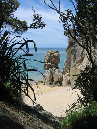
Here is another look at a beach and an interesting granite rock structure. Granite predominates throughout the park.
The other interesting part of this track was the tidal crossings. You had to plan your hike and your campsites based on the tides, because there are two or three estuary crosssings that can only be crossed within 2-3 hours of the low tide. The tidal swings in this area are huge. 3 meter tidal changes. Making some at high tide impassible, or requiring a very long high tide walk-around route, potentially adding hours to your day. Here is a shot of Keith crossing the first big one, and the only one that didn't have a high tide route, so you had to time this one right. This ended up being the end of our first day, and you can see the hut ahead of Keith. We didn't stay in the huts, but usually camped very close to them.
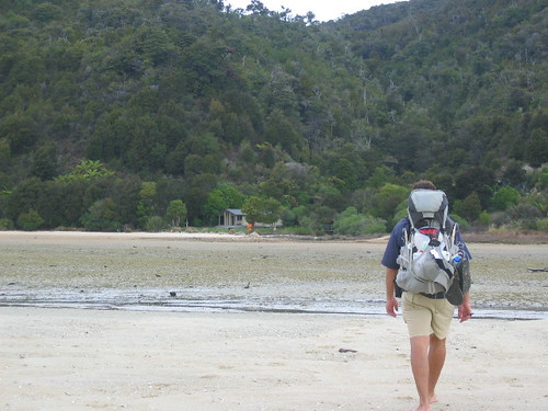
What was really fascinating at this camp in particular was watching the time come back in. All of where Keith is standing in that picture eventually became a huge river. We could literally see the tide come in. We'd stand about 3 feet from the water's edge, and within 30 seconds the water would be at our feet. And the bubbling sounds coming from all the clam holes was unreal (the sand we walked on here was littered with steamer clam shells). We should have shot a video of it.
Don't know what else to say about the hike. Pretty nice the whole way. Lots of ups and downs like any coastal hike will be and lots of walks along the beaches as that is where the trail runs. New Zealander's have the tramping thing down. The trails are in excellent condition and the campsites and hut sites are very well equipped with flush toilets at most and filtered water at quite a few. Of course this is one of the most popular hikes so it also heavily regulated - we got checked for our permits each night.
We also learned what we already knew and that is that it has been a LONG time since we have done an overnight hike. We felt it the first day. Either that or we are just getting old. A combo of the two I am sure.
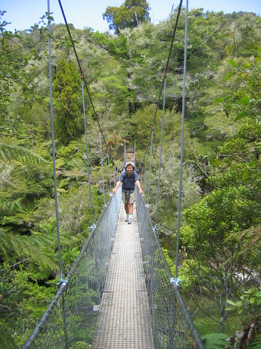
Here is a shot of the suspension bridge we crossed on the second day:
And a look at the beach where we camped the second night. Pretty nice, eh?
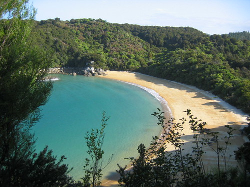
Here's a sunrise I stumbled upon when I got up for an early morning trip to the "loo".
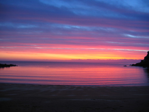
And finally at the trails end, waiting for the bus, trying to recover with the infamous cappucino.
We checked into another lovely hostel, and got some invaluable information about the trail from the Info center and worked out our transportation for the next few days. We stumbled upon another great deal and were able to get a free rental car for our transport back out of Motueka (after the hike) and to Picton where we were meeting John and Jenn. A pathetic car, really - like a Geo, but free is free (someone ditched a rental in Motueka and the company needed someone to drive it back to Picton).
That was a bunch of nonsense really, I suppose the hike was more interesting than all of that jibber jabber. Adn a lovely hike it was. 51 km total, hiked over 3 days, 2 nights. The weather was great. Sunny and hot the first day, cloudy and cool the second, and somewhere in between on the third. It never did rain however. As the name implies it is a Coastal track, so it follows the coastline af the Abel Tasman National Park which sits on the East side of the northern most peninsula of the north island. The best way I can describe the scenery and climate is to say it is a combination of Hawaii and the Pacific Northwest. The scenery looks like Hawaii - white sand pristine beaches and bright blue water, surrounded by subtropical forests; but the temperature of the water and surrounding air is much like that of the NW. Not a bad combo if I do say so myself. I think when the warmer waters arrive in the summer, they become much more swimmable beaches. So as you start the track (which we did from north to south), you see these beautiful beaches, and of course we take pictures of them all and try to walk on as many of them as we can, but then towards the end of day 2, you start to take the beaches for granted and don't worry too much about missing one or two of them.
Here's a look at one of the beaches from afar:
Here is another look at a beach and an interesting granite rock structure. Granite predominates throughout the park.
The other interesting part of this track was the tidal crossings. You had to plan your hike and your campsites based on the tides, because there are two or three estuary crosssings that can only be crossed within 2-3 hours of the low tide. The tidal swings in this area are huge. 3 meter tidal changes. Making some at high tide impassible, or requiring a very long high tide walk-around route, potentially adding hours to your day. Here is a shot of Keith crossing the first big one, and the only one that didn't have a high tide route, so you had to time this one right. This ended up being the end of our first day, and you can see the hut ahead of Keith. We didn't stay in the huts, but usually camped very close to them.
What was really fascinating at this camp in particular was watching the time come back in. All of where Keith is standing in that picture eventually became a huge river. We could literally see the tide come in. We'd stand about 3 feet from the water's edge, and within 30 seconds the water would be at our feet. And the bubbling sounds coming from all the clam holes was unreal (the sand we walked on here was littered with steamer clam shells). We should have shot a video of it.
Don't know what else to say about the hike. Pretty nice the whole way. Lots of ups and downs like any coastal hike will be and lots of walks along the beaches as that is where the trail runs. New Zealander's have the tramping thing down. The trails are in excellent condition and the campsites and hut sites are very well equipped with flush toilets at most and filtered water at quite a few. Of course this is one of the most popular hikes so it also heavily regulated - we got checked for our permits each night.
We also learned what we already knew and that is that it has been a LONG time since we have done an overnight hike. We felt it the first day. Either that or we are just getting old. A combo of the two I am sure.
Here is a shot of the suspension bridge we crossed on the second day:
And a look at the beach where we camped the second night. Pretty nice, eh?
Here's a sunrise I stumbled upon when I got up for an early morning trip to the "loo".
And finally at the trails end, waiting for the bus, trying to recover with the infamous cappucino.
Pictures of Ferry Ride
Sorry for the hiatus. Back online in a big city, and able to get some pictures up. I'll do the updates piecemeal, so as not to overwhelm with one big entry.
Word of note - you can always assume it is me, Emily, writing these entries until otherwise noted, as I can't seem to get Keith to do an entry. His excuse has to do something with his inability to type as fast as I do. We'll get him on here one of these days, so hope my writing isn't too drab.
Anyway, here is a picture of the ferry we rode on to get to the South Island, and a view from the ferry.
Another Interislander passing us in the narrow channels of the Marlborough Sounds:
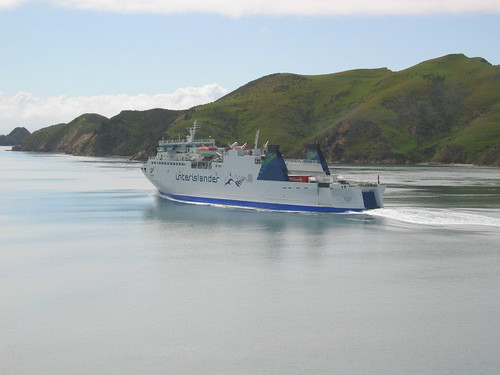
And here is the view just after crossing Cook Straight, and coming into the Marlborough Sounds. Quite a narrow entry way into the sounds. There is currently a legal battle between the residents of the Sounds and the Ferry company. The Ferry would like to add another ferry run to their schedule, but are currently prohibited from doing so as they are not allowed to drive the boats above a certain speen through the Sounds. The increased speed causes too much damage to the coastline causing it too erode away quickly.
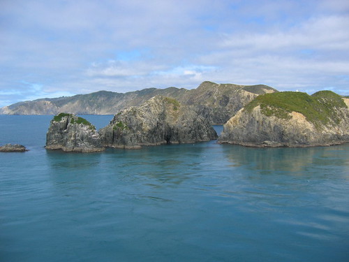
Word of note - you can always assume it is me, Emily, writing these entries until otherwise noted, as I can't seem to get Keith to do an entry. His excuse has to do something with his inability to type as fast as I do. We'll get him on here one of these days, so hope my writing isn't too drab.
Anyway, here is a picture of the ferry we rode on to get to the South Island, and a view from the ferry.
Another Interislander passing us in the narrow channels of the Marlborough Sounds:
And here is the view just after crossing Cook Straight, and coming into the Marlborough Sounds. Quite a narrow entry way into the sounds. There is currently a legal battle between the residents of the Sounds and the Ferry company. The Ferry would like to add another ferry run to their schedule, but are currently prohibited from doing so as they are not allowed to drive the boats above a certain speen through the Sounds. The increased speed causes too much damage to the coastline causing it too erode away quickly.
Subscribe to:
Posts (Atom)