Happy Thanksgiving! As I type this you all back home are enjoying cozy, turkey dinners with friends and family. I hope you are all enjoying!!
We're back from our 6 day adventure in the southland sounds and alpine areas. If you want to cruise on down to the last entry about the Kepler Track, I've put some photos up. We are in Queenstown right now - still on the southwest corner of the South Island. Queenstown is another tourist/adventure haven. We're just lying low and resting, bypassing the touristy stuff. We only have 6 days left and have decided to rent a car for those days so we can stop along the way without having to spend so much time figuring out bus schedules and how to get to the last few side trips we want to do. Being on the south part of the island is an advantage as well, because you can get nice deals on rental cars. The companies need their cars moved back up north because so many travelers travel from north to south, then fly out. Anyway, below is again my journaling of the hiking and kayaking we did. Again, it may be too boring for most. The Readers Digest version is that everything went well and was beautiful, except for one miserable day on the trail, where we got a taste of the unpredictable, at times unpleasant NZ weather that everyone keeps warning us about. So read on at your own leisure.....
Sat, November 19, 2005:
The dramatic beauty of the Milford Sound. We got to see it by kayaking rather than aboard one of the many cruise ships that make their way around the sound - or is it a fiord? The technical definition of a sound is a water filled valley that was carved out by a river. And a fiord is one that was carved out by a glacier. (Am I right dad?) The valleys of where we kayaked were carved by glaciers, so technically it should be called the Milford Fiord, right? Well, our guide today said they have compensated for this fact by naming the whole area Fiordlands National Park. Whatever the correct geological name, it was stunning. The Milford Sound is one of the only of the many sounds that line the West Coast of the southern half of the south island that is accessible to people by car. Doubtful Sound is the other one and requires a long drive, a boat ride, then another drive over a pass. The land is quite remote here. You can get to other parts of the park also by helicopter or plane, by walking some very difficult tracks, or by boat via the Tasman Sea.
Even getting to Milford is a bit of work (or time at least). From Te Anau (the last major town before the sound) it is about a 2 hour drive to Milford Sound via what is supposedly the famous Milford Road. A very long, winding and beautiful drive. We got picked up at the ungodly (for us vacationers anyway) hour of 6:30 AM by the kayak company to make the journey. The first part was nondescript, but once we started gaining elevation and after passing through Homer Tunnel, we started getting more dramatic views. Eventually we had our first view of the sound and it was a beaut. Essentially, it looks like mountains that have been submerged. Very steep, tree-covered cliffs that plunge right into the water and peaks towering high above.
The weather was marginal. Cloudy, and looking like it could rain at any time, but very calm water. We got geared up, safety talk done, then hit the water. Keith and I in a double and three other couples and our guide. We took our time circling the sound and enjoying the views. Of course Keith and I would have liked to have gone further out into the sound, but that is one of the problems with guided tours - you have to go where they tell you. On the other hand our guide was awesome and gave us lots of good information about the area. For wildlife we saw lots of penguins and one seal. We had a leisurely lunch stop, a peak at where the famous Milford Track ends, then were back to teh docks by 3:00. We never did get rained on - it got a tad bit windier, but no rain which was nice. The sandflies down here though....yikes are they bad! There's a Maori story saying that one of the gods created them to keep people away from the beauty of the area so as not to destroy it.
Here's us in the kayak:
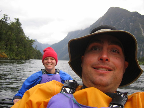
And a view of Mitre Peak - one of the most photographed parts of the sound:

After kayaking we had a quick tour of Milford, which consists of a pub, a lodge, and a cruise boat terminal where 6,000(!) people a day take motor boat cruises around the sound. The van stopped to take in some views on the way back, and some hot drinks and biscuits (cookies), then we got dropped off at the Divide (where the mountain ranges split the east and west sides of the island). From here we started our 5 day hike.
The original plan was to just do the Routeburn Track - another Great Walk. But it is not a loop track and the logistics of getting back to where you started to pick up the rest of your stuff is a nightmare and a ton of driving. So we created our own loop track by combining the Caples Track with the Routeburn, which only involved one shuttle (and a stay in a lodge!) to get from the end of the Caples to the beginning of the Routeburn. So to start we headed up the Routeburn from the Divide for about an hour after which we turned off onto the Greenstone/Caples track. This portion was not a Great Walk so camping is free and the huts are much cheaper at only $10 per person. 20 minutes into this trail, we arrived at our campsite for the fist night. We brought our tent and sleeping pads in this far, close to where the trail divides, with the plan to stash them, stay in huts the rest of the time and pick them up on our way out.
There is one thing I think I forgot to mention about the Kepler Track and great walks in general. While you do have to pay a premium, what you get for it is almost worth it. The huts are very well set up with sleeping bunks (with nice pads), cooking facilities, drinkable water, flush toilets. What this means is you save a LOT of weight by staying in them, and packs become considerably lighter. We became quite spoiled in this way on the Kepler, so we opted for the huts the rest of the way on this walk for the weight factor as well as the unpredictable weather factor. Tents can only stay dry for so long.
So there you are, rambling as usual. We got to camp by 6:00 PM and set up the tent just as the rain started. We ate dinner, and quickly climbed in to sleep. The forecast calls for rain all day tomorrow, so we are preparing for the worst, but hoping for a break.
Sunday, November 20, 2005:
We we knew if we kept glowing about how lucky we have been with the weather it was going to come up and bite us in the ass at some point. Unfortunately the forecast was dead on. It rained ALL DAY today. Not even a pause. We got absolutely soaked. Our worst day hiking probably ever (although as I sit here typing this now, it doesn't seem like it was all that bad). I guess we couldn't come away from NZ without one hike like this. Glad it wasn't on the Routeburn where the truly spectacular views are supposed to be. It rained all night on us, and I think the guy at customs who washed our tent, washed some of the waterproofing off because by morning rain was starting to drip through. We woke up early but stayed in bed waiting for "the rain to stop". Ha. We'd still be lying there waiting!
We finally bit the bullet, donned all the raingear we had (of which Keith has very little). I just bought some waterproof pants, and boy am I glad I did. We packed up quickly, stashed the tent and off we went. Given the pounding rain, gusty wind, and knowledge that we had to go up and cross over a saddle, I sort of wanted to go on the other track that follows another river (but would entail more mileage). However, since we forgot the maps (just what our parents want to hear - lacking in raingear, alpine crossings and no map) we didn't know if we'd make our bus on the other side, so we stuck with the original plan. We quickly learned the defnition of Great Walks (of which this isn't). Great Walk = great track, great track maintenance, great signage, and great huts. This trail sucked. Very narrow, steep, and completely root laden. Anyone who has hiked at all, knows how slippery a wet root can be. That is all we've been walking on is roots. We did OK the first hour dealing with it all. As we got closer to treeline, I started to break down (I think I was literally whimpering there for a second).
Then we broke treeline and yes, the wind was fierce and the rain harder and colder. But Keith assured me we wouldn't be up there long and the trail had miraculously become easy walking. So we booked it, finally being able to walk faster and our spirits a little lighter (this is 2.5 hours from the start). Then we started heading back down into the valley on the other side and lo-and-behold the trail begain to deteriorate again. They did have good markings on the trees so we were never in danger of losing the trail, it was just really hard walking. At this point Keith's jacket is starting to soak through and my waterproof shoes are no longer waterproof. At about 3 hours from start, and know Keith is having a little breakdown as he is pretty much soaked from head to foot. We are both tired and the rain shows no sign of letting up. I have got to hand it to the polypro/fleece/wool gear - you do stay warm, even when wet. Moving helps of course as well. I thought my hands would be goners buy I kept my saturated fleece gloves on and they (my hands) stayed warm the whole time.
Eventually, we both stopped complaining and buckled down and dealt with the misery of it and had as much fun with it as we could. With less trail maintenance comes river crossings with no bridges and that pretty much sealed the deal for wet feet. That and the fact that our trail was a river itself half the time. Keith only managed to fall once due to a faulty boardwalk, Em three times. We stopped once to use the loo, otherwise we motored on through to the hut arriving at about 2:30 (5 hours of walking in the rain). What a beautiful sight it was. There was one other guy there and he already had a fire going. Upon changing into dry clothes (the garbage bags worked like a charm) we both realized just how wet we were. We got things hung up to dry and are now settled in quite snugly to this humble hut (Upper Caples Hut). It is a smaller hut but has all the same amenitites except for gas cookers and a flush toilet. Anything with a roof and a fire is fine with me at this point.
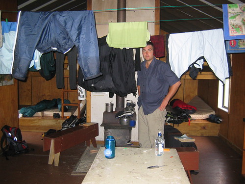
Here's Keith monitoring the drying of the clothes in the Upper Caples Hut:
Monday, Nov 21, 2005:
The rain finally quit late in the evening last night and we got some nice views of the cliffs surrounding us. Keith managed to get a decent size coal fire stoked upa nd it seemed as if our stuff just might dry. Another gal joined us, arriving late, and just as wet. A very pleasant evening was spent in what was a much cozier hut than the big guns on the Great Walks. We slept well, woken only by the frequent and loud rain showers, but were pleased to wake to no rain. The skies weren't clear, but they were much less angry than yesterday giving us hope for a dry walk out. Regardless - we would have been more tolerant of rain as at the end of the day we have a room booked at what people have been calling the cozy and quaint, lovely Kinloch Lodge.
As it turned out, we barely got drizzled on and had a very nice, easy hike out. Teh walk was mostly out of the woods in a wide open very pretty valley following right along the Caples River. Even though the trail was quite easy walking, we were both quite tired - physically and emotionally wiped from teh day before is all we could figure. Lovely scenery the entire way (except for teh dead cow right on the trail!) and we were at the trailhead/carpark with a half hour to spare before our shuttle arrived. Teh shuttle turned out to be a boat ride that dropped us in Kinloch which amount to the lodge and two houses.
Kinloch lodge is a great place. They have a whole range of accomodations from deluxe, all inclusive to backpacker/hostel style. We stayed in our usual double room with shared facilities, butthe rooms are much nicer than any hostel we've stayed at yet. There is an onsite restaurant, all the usual facilities (TV room, kitchen, living space), but the best part (and most needed) was the hot tub! Ahhhhh!!!!
The wind was amazingly strong all night and quite cold which had me a bit worried about our high elevation hike. We'll see what tomorrow brings, in the meantime we're making the most of these facilities - which includes getting our stinky clothes freshened up again.
Tuesday, Nov 22, 2005:
We awoke thi smorning to clear, blue skies and calm air. Yay! We got all checked out an dafter splurging on a cup of coffee were off in another shuttle headed to the Routburn trailhead. We started our hike at about 10:15 and could already tell it was going to be a much more crowded trail than any other so far. But if the mountains we saw on our drive to the trailhead were any indication, we could also tell it was likely going to be even more scenic than any others as well.
The climb up here to Routeburn Falls Hut was relatively easy, taking only about 3 hours and was absolutely stunning (the clear day helped of course). Valleys and waterfalls, turquoise rivers, and snowcapped rugged mountains teh whole way. There are lots of guided walks on this trail, so we passed many large groups moving quite slowly. There is also an option to walk the entire track guided and stay in private huts along the way....for a measly $1200. Apparently you get fancy meals cooked for you and I'm assuming much warmer and more pleasant sleeping quarters than un independent walkers get.
This hut sits right on a fairly steep cliff just below Routeburn Falls and overlooking the valley from whence we came - in other words great views to read your book and sip your hot chocolate by. We got here so early that after claiming our bunks, we walked up the trail a bit further to catch some more views just in case teh weather turns on us tomorrow and blocks it all. Forecast for tomorrow is confusing, but calling for some not-so-nice stuff. We'll see.
Wed & Thurs, Nov 23 & 24, 2005:
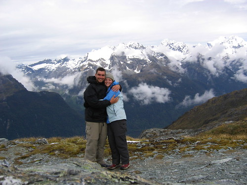
I write this from the parking lot - the beginning and end of the Routeburn Track and our major tramping in NZ. We ended with a fabulous 2 days of hiking . Yesterday's forecast was quite glum - lots of nasty talk about southwesterlies blowing in and rain easing off to showers by the afternoon. The skies were clear when we woke up, so we headed off quickly wanting to get to the top of Conical Hill (a side trip that offers spectacular 360 views) before these southwesterlies moved in. We lucked out again. It was a cloudy day, but the clouds stayed high enough that we still got all those great views. Check out us on top of Conical Hill:
And the rain didn't come until we were well settled into our hut at McKenzie Lake. When the weather is fine and the hiking is superb, there isn't much to say. This truly was teh most stunning hike we did and a great one to end on. Yesterday's walk took us climbing out of the waterfall-laden basin where our first hut sat to the ridge that overlooked teh Hollyford Valley and lots of dramatic, steep snow capped mountains. The rest of the day followed along that ridge for about 8 km until dropping back down to McKenzie Lake and our hut. The walking has been relatively easy and we've been getting to the huts or carparks by about 2:00 with leisurely breakfasts and lunch stops. Pretty nice - almost need the hiking days to be a bit longer.
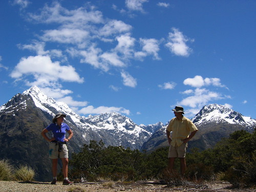
After a little rain last night, we woke to a very crisp morning, but with the bluest of skies and warm sun once we got out into it. The hike today had us climb back out of the valley briefly for a few last glimpses at the mountains, then spent the rest of the time gradually heading down through the trees to Howden Hut. From there (where Keith made the short jaunt back down the Caples track to get our tent). From there we took one more side trip up to another hill with more views, then back to the carpark. Here we are on that side track, called Key Summit contemplating the beauty of it all:
Just gorgeous. Now we wait for the bus and the four hour drive to Queenstown. (Carl and Tory....I highly recommend this hike as one for you to do if end up in NZ! I would do this one over the Kepler if you are limited on time. Much more dramatic scenery.)
1 comment:
Perhaps an illusion but you two seem to be very close to the same elevation as those snowy peaks in the first mountain photo. The mountains look so majestic, rugged and icy, and in bad weather must have seemed threatening to be up there.
Coos girl
Post a Comment